Oman’s Geology Uncovered: From Prehistoric Caves to the Arabian Plate
Oman is a land where geology and history intertwine. From awe-inspiring caves hidden within its mountains to landscapes shaped over 800 million years, the Sultanate offers one of the richest natural heritages in the Arabian Peninsula. Travelers, scientists, and adventurers alike find Oman a living museum of Earth’s past—where rock formations, ancient artifacts, and underground wonders tell the story of humanity and the planet itself.
The History of Oman’s Caves
Caves in Oman are more than geological formations—they are cultural and historical landmarks. For thousands of years, they served as shelters, storerooms, and even places of worship for early inhabitants. In caves across Dhofar and the Hajar Mountains, archaeologists have discovered rock carvings and inscriptions depicting conflicts, rituals, celebrations, and signs of territorial ownership.
Evidence suggests that modern humans lived in southern Arabia over 100,000 years ago. Paleolithic stone tools scattered near caves in central and southern Oman confirm this deep history. Later, during the Neolithic era, caves were used to store food, weapons, and livestock. Some caves became so important that their names were widely known, acting as reference points for travelers navigating the rugged mountains.
In addition to shelter, caves were valuable resource hubs. Bird droppings (guano) collected from cave floors were used as fertilizer and later in gunpowder production. Excavations have uncovered traces of palm fronds once used for lighting, as well as evidence of copper and guano mining—demonstrating the resilience of Omanis in extracting resources from these difficult environments.
During the Bronze Age and early Islamic periods, Oman developed advanced copper mining and smelting techniques. Caves near Sur and Al-Amerat reveal artifacts, pottery, and smelting slag from these eras, highlighting Oman’s role in early metallurgy. Even as late as the 20th century, caves such as Al-Ma‘āwil served as homes, water sources, and livestock shelters. Some elders in Al Jabal Al Akhdar recall being born in caves still preserved today.
Legends, Science, and Exploration
For centuries, folklore about spirits and jinn kept many people away from caves. But from the mid-20th century onwards, scientists and explorers began documenting them systematically. Stalactites and stalagmites (speleothems) inside caves provide climate data through stable carbon and oxygen isotopes, allowing researchers to reconstruct ancient climate shifts over the last thousand years.
Caves also hold ecological treasures. The famous Al-Hoota Cave near Al Hamra is home to the rare Omani blind fish (Garra barreimiae), a species found nowhere else in the world. Karst systems in Oman also help scientists map groundwater reserves—knowledge vital for managing the country’s precious water resources.
How Oman Emerged on Earth’s Surface
Oman’s natural story stretches far beyond human history. Geologists trace the country’s origins to over 800 million years ago, when tectonic forces shaped continents and ocean basins. Over time, Oman’s crust was submerged under ancient seas, folded into mountain ranges, and shifted across the globe—from near-polar latitudes to the equator.
This geological journey exposed Oman to ice ages and tropical climates, leaving behind fossils, mineral deposits, and unique landforms. Today, Oman sits on the Arabian Plate, a relatively stable tectonic block compared to its seismically active neighbors.
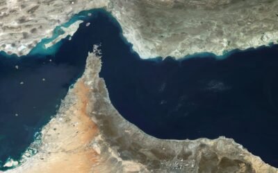
Oman’s Geological Borders
- North: The active Zagros and Makran mountain belts occasionally trigger mild tremors in Musandam.
- East: The Owen Fracture Zone lies deep in the Indian Ocean, with little impact on Oman.
- South & West: The Red Sea and Gulf of Aden continue to rift, slowly separating Arabia from Africa.
Though stable today, history records destructive earthquakes, such as the one that struck Qalhat around 600 years ago.
From Geology to Modern Development
Geologists study Oman’s landscapes using tools ranging from satellite imaging to electron microscopes. Deep drilling and seismic surveys have revealed valuable insights into subsurface resources. This knowledge played a critical role in Oman’s modern economic renaissance, especially after 1970, when oil and gas exploration transformed the country’s future.
By applying geological sciences, Oman successfully tapped into hydrocarbons and minerals, linking its ancient natural history with modern progress.
A Land of Timeless Heritage
From prehistoric tools in mountain caves to evidence of tectonic shifts spanning hundreds of millions of years, Oman is a destination where the story of Earth unfolds before your eyes. Its caves, fossils, copper mines, and mountain ranges are not only scientific treasures but also cultural and touristic assets that showcase Oman’s unique place in the natural world.
Hassan Al Maqbali
Content Creator & Website Manager at Omanspire
Hassan Al Maqbali is a dedicated content creator and the website manager at Omanspire, where he writes passionately about Oman's culture, history, and the timeless stories that shape the nation’s identity. His work reflects a deep love for the Sultanate and a commitment to sharing its beauty with the world.
Driven by a desire to widen global understanding of Oman, Hassan creates narratives that present the country through diverse perspectives—capturing its people, heritage, landscapes, and evolving cultural heartbeat. Through Omanspire, he hopes to bring readers closer to the spirit of Oman, one story at a time.